Navigation and GNSS in Smart Cities: Testbed concept definition
Programme Reference
T606-507ET
Status
Closed
Country
Spain
Start Date
2018
End Date
2020
Programme: TDE Prime Contractor: ROKUBUN S.L.
Subcontractors:
Istituto Superiore Mario Boella • Italy
POLITECNICO DI TORINO • Italy
Traffic Network Solutions S.L • Spain
UNIVERSITAT AUTONOMA DE BARCELONA • Spain
Objectives
The first objective is design of a testbed to support future applications of GNSS and other positioning systems in Smart Cities, as well as the feasibility analysis of its future implementation. The second objective is the development of a software simulation platform : (i) cloud-based techniques for the detection and localization of GNSS jammers based on snapshots of the GNSS signals (ii) cloud-based techniques for the positioning of devices based on snapshots of real GNSS RF signal in harsh propagation conditions. The third objective is to translate the outcome of this activity into recommendations/requirements for GALILEO 2nd generation user performance and signal design.
Description
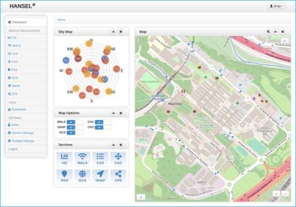
GNSS and other positioning systems are expected to have a very important role in Smart Cities. In this context, the design of the high-level architecture of a testbed to support future applications of GNSS and other positioning systems in Smart Cities is of high interest. The design of this testbed shall consider as baseline the availability of a network of distributed smart sensors, which are remotely accessible and configurable from the cloud, and existing network infrastructures shall be considered. The capabilities provided by the smart sensors shall be identified in order to cover different target applications. Any sector that could be benefit from the usage of navigation information shall be considered. In terms of technology, the exploitation of both GNSS and terrestrial positioning systems shall be taken into account. Furthermore, the mechanisms to manage and efficiently exploit the data from the sensors in the cloud shall be defined and preliminary assessed. Based on the previous analysis, a preliminary definition of Smart City navigation-based applications and the corresponding feasibility analysis shall be provided. In parallel to the definition of the testbed, the following two use cases envisaged shall be implemented in a software simulation platform in order to show the potential of GNSS in Smart Cities: i- Cloud-based localisation of GNSS jammers: analysis, design and concept demonstration : the detection, monitoring and localization of GNSS jammers might be a need due to the increasing services and applications relying on the GNSS signals for its operation (e.g. mobile communication base stations). In this context, the current evolution of cloud computing and the Internet of Things (IoT) with future devices connected to the Internet and applications running in the cloud makes feasible to thing about a cloud-based localization of GNSS jammers. A series of GNSS sensor devices are connected to the internet and are able to send to the cloud snapshots of the GNSS signal received which eventually might contain as well interference signals. Those signal snapshots then can be processed in the cloud in a coordinated way in order to, not only be able to estimate the device position and timing information, but also detect and localize jammers or any interference sources transmitting in the GNSS frequency bands. The localisation of one or multiple GNSS jammers in the same scenario shall be considered in the activity. At least power, TDOA and FDOA measurements shall be considered in the detection and the position estimation. Both fixed and mobile GNSS sensors and GNSS jammers shall be considered. ii- Cloud-based GNSS positioning: analysis, design and concept demonstration : Cloud-based GNSS positioning can be of high interest for some particular applications in which size, power or computational constraints might be present. Furthermore, the processing at the cloud can be useful for the application of computationally demanding techniques, like high-sensitivity techniques for harsh environments or innovative interference mitigation techniques. On the other hand, the availability of signal snapshots from different users and, therefore, from different positions, might be useful for the exploitation of future GNSS applications in the Cloud. In particular, cooperative positioning might be applicable by exploiting the GNSS signal snapshots and additional navigation information provided by the users, going toward cognitive positioning system. The results of this activity shall be considered an input to the consolidation work performed as part of the GALILEO 2nd generation system design, in the area of signal design and user performance.
• Application domain: Navigation
•
Technology Domain:
6 - RF Subsystems, Payloads and Technologies
6 - RF Subsystems, Payloads and Technologies
•
Competence Domain:
5-Radiofrequency & Optical Systems and Products
5-Radiofrequency & Optical Systems and Products
• Initial TRL: TRL 1
• Target TRL: TRL 3
• Achieved TRL: TRL 3
•HarmoRoadMap: N/A
•IPC Document: ESA/IPC(2017)3
•Public Document: