Using GNSS and Big Data Techniques to improve safety in critical maritime operations
Programme Reference
15/114
Status
Closed
Country
Italy
Start Date
2017
End Date
2019
Programme: Discovery Prime Contractor: SATE
Description
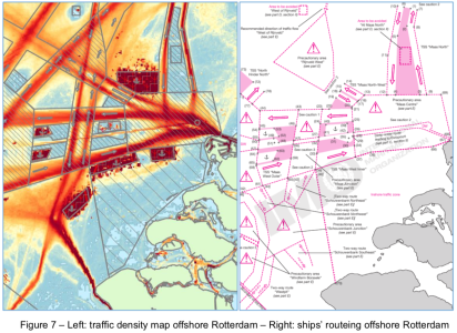
This project was intended to contribute to the implementation of the e-navigation concept (as defined by IMO, Ref. 2.2.6), with primary focus on the navigation in restricted waters, such as harbours, lagoons or regions where the traffic congestion can create conditions for accidents or inefficient operations.It must be clarified that, in the context of restricted navigation areas, there exist a limited number of possible water ways. These can be the result of morphological characteristics of the basin, such as in the Venice harbour that is inside the lagoon, or practical constraints that the port authorities impose to effectively and safely manage ship traffic, such as in large harbours. Besides the peculiar situation of Venice, it must be remarked that large ships have limited access areas also in large harbours due to their draught and the, sometimes, limited dredging activities by port authorities.Indeed large ships, such as deep sea container vessels, having a length of up to 400 m and a lateral windage area of up to 12 000 square metres, and large bulkers or tankers with a draught of up to 22 m face restrictions on path, tidal level and water depth and challenging meteo-ocean conditions (wind, fog, tidal current and waves) when entering and leaving a port. On top of this there are special regimes for vessels with dangerous cargo such as the large LNG-carriers and the smaller LNG bunker barges that are now entering the large European ports.
• Application domain: Navigation
•
Technology Domain:
10 - Flight Dynamics and GNSS
13 - Automation, Telepresence & Robotics
10 - Flight Dynamics and GNSS
13 - Automation, Telepresence & Robotics
• Initial TRL: TRL N/A
• Target TRL: TRL N/A
•Public Document: