
Automated monitoring of geohazards using Sentinel-2 time series in montainous regions
Slow-moving landslides are of particular threat in many areas around the world, with large impacts on infrastructures and populations. In this project, we aim at developing the tools to detect them and monitor their activity with time, using optical sensors.
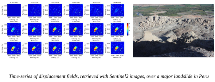
A method dedicated to the landslide monitoring from repeat optical satellite images (TIO) is developed based on the inversion of a redundant system of multi-temporal displacement fields. We validate the time-series of displacement by comparison of the Sentinel-2 and GPS data, installed on 3 landslides in Peru. This shows uncertainties of between 40 cm and 2 m for all the measurements. TIO is integrated on the GEP platform.
The detection of landslides is then achieved by optimization of the time-series of displacement fields, under specific constraints. This original method, applied on old SPOT1-5/Pléiades images over the Colca valley in Peru, re-sampled at 10 m to simulate the Sentinel-2 datasets, shows its ability to detect large previously known landslides and detect smaller unknown ones.
Training of peruvian colleagues to the different methods developed were finally undertaken in the framework of this project.