InSAR based tarrain motion mapping in support of landslide hazard assessment in high mountain areas
Programme Reference
AO5-e
Country
Switzerland
Start Date
2016
End Date
2017
Programme: Discovery Prime Contractor: UNIVERSITY OF ZURICH
Description
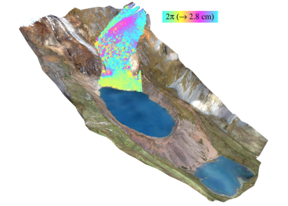
Landslides are a well-known but so far less-investigated hazard and risk in the Cordillera Blanca. In this pilot study, EO information in combination with in-situ measurements and modelling was applied for investigating and monitoring landslide processes in this mountain region.
Landslides pose significant hazards and risks to the densely populated mountain region of the Cordillera Blanca in Peru, with a series of catastrophic events in the past. In this Alcantara pilot study, value-added information was generated by combining DInSAR-based products with optical EO data, aerial and terrestrial surveys, structure-from-motion applications, as well as different types of slope stability models. This information was applied to investigate landslide processes at selected study sites, design and implement terrestrial survey strategies and a multi-source landslide monitoring system at one of the sites. InSAR analyses in combination with field investigations and historical aerial photographs was further used to inform numerical models for simulations of glacier lake outburst processes. Finally, the potential of EO contribution to landslide Early Warning Systems, a prevailing topic, was analysed and presented in a white paper, considering both conceptual considerations as well as practical implementation aspects.
• Application domain: Generic Technologies
• Initial TRL: TRL N/A
• Target TRL: TRL N/A
•Public Document: