Tackling the plastic debris challenge at its source – Linking EO data with multi-source in-situ data for modelling debris pathways from source to sink
Programme Reference
20-D-T-TEC-01-o
Status
Closed
Country
Germany
Start Date
2020
End Date
2022
Programme: Discovery Prime Contractor: RSS
Description
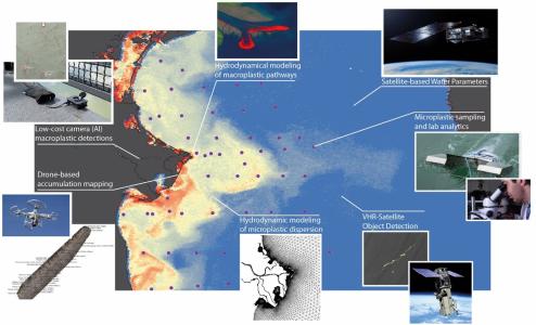
Monitoring areas closer to plastic marine litter sources that can be very well targeted, such as rivers and estuarine systems, has the potential to improve mitigation strategies, since they can be spatially focused and even clean-up activities can be more efficient. Recent studies showed that floating plastics emitted from the coast depict a much greater chance to rapidly return to land with most litter stranding within a short distance of the river mouth. Our knowledge about the source, amount and spatial variability of both macro- and microplastic in aquatic ecosystems is still limited, partially due to analyses being based solely on in-situ point measurements. In-situ data are an important component for monitoring plastic debris, but these data alone cannot capture highly complex source-sink relationships.Upscaling in-situ point data of litter with Earth Observation (EO) and hydrodynamic models was the central concept of the project. From source to sink (from river - to ocean - to coast), a wide range of technologies were for the first time tested together, starting with low-cost camera systems operated from bridges above the Po river, in order to identify floating macroplastic particles in the images using artificial intelligence (Faster-RCNN). The number of observed particles were used as input to seed the macroplastic transport model “HYDROMOD-Tracer”, which provides transport pathways for the particles. In addition to the macroplastic, the in-situ microplastic data collected via manta trawls in the river itself as well as in transects in the open ocean along the coastline, could calibrate and validate the hydrodynamic model (Regional Ocean Modelling System, ROMS) and the Lagrangian model to simulate the dispersion pathways of microplastics (ICHTHYOP). The collected in-situ microplastic samples that have been analyzed using FTIR (Fourier Transform Infrared) spectroscopy, allowed us not only to quantify the abundance of microplastic and define the plastic type, but also to identify near-shore fronts with a high abundance of microplastic debris. The locations of these fronts have also been proved by the use of satellite-based total suspended matter information. Along the further transportation pathway, drones were used at potential hotspots of accumulation zones with expected high rates of beached plastic particles. With the acquired drone imagery, microplastic particles were automatically classified to quantify the abundance of plastic litter along the shoreline. A monitoring system able to predict entry points, dispersal trajectories and accumulation areas can offer an innovative, versatile tool for coordination of both abatement and removal measures. Our project therefore prototyped a modular monitoring system, for the first time bringing a wide range of technologies together that can lead to a holistic source-to-sink monitoring. With additional research, development and test activities in the future, this monitoring concept can lead to an operational system that provides continuous spatial information crucial for entities and stakeholders involved in the mitigation and removal of plastics in the environment.
• Application domain: Earth Observation
• Initial TRL: TRL N/A
• Target TRL: TRL N/A
•Public Document: