Mapping Windrows as Proxy for Marine Litter Monitoring from Space Remote sensing for marine litter - WASP
Programme Reference
20-D-S-TEC-01-b
Status
Closed
Country
UK
Start Date
2022
End Date
2022
Programme: Discovery Prime Contractor: ARGANS LIMITED
Description
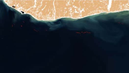
WASP is a prototype EO data processor, developed in the frame of the ESA Discovery Campaign on Remote Sensing of Plastic Marine Litter, exploiting Copernicus Sentinel-2 L1C images to detect and catalogue the presence of filaments of floating marine debris with high probability of containing anthropogenic litter. WASP takes advantage of lessons learned in the frame of the ESA project ‘Earth Observation (EO) Track for Marine Litter (ML) in the Mediterranean Sea’, which successfully proved, for first time, that Copernicus Sentinel-2/MSI data can detect the presence of floating matter and marine litter accumulations as proxies of plastic litter content. The entire Copernicus Sentinel-2 archive over the Mediterranean Sea was processed, and following an in-depth analysis, a database of the identified proxies was created over the area. The final product is a map of sub-mesoscale marine debris concentrations in the Mediterranean Sea based on Copernicus Sentinel-2. The product consists of a census of these structures for each processed tile for the Mediterranean Sea, with potential for global scalability.
• Application domain: Earth Observation
• Initial TRL: TRL N/A
• Target TRL: TRL N/A
•Public Document: