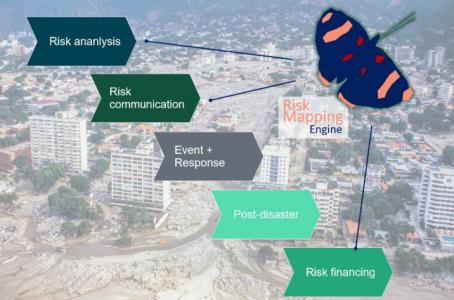
Risk Mapping Engine
Programme Reference
GT21-019ES
Status
Closed
Country
Spain
Start Date
2018
End Date
2020
Programme: GSTP Prime Contractor: INDRA SISTEMAS
Objectives
The objectives of the activity include: Access automatically to EO data and other relevant geospatial data Integrate in the workflow of the engine platforms and COTS of Earth Observation and Geographic Information Systems Generation and/or use of hazard information from EO observable information both about Inland/coastal flood (statistics on maximum water extent) and landslides (empirical model based on deformations) Capacity to generate information of elements at risk and vulnerability including workflows to generate selected elements at risk mapping as well as characterize the vulnerability of assets/population using selected available models Capacity to produce automatically risk maps using multi hazard (floods and landslides), exposure and vulnerability information Allow the system’s users to request and visualize services on demand and perform specific analytics
Description
The use of analytics functions with EO and non-EO data will bring the following benefits: Capacity to characterize the vulnerability of assets/population using selected available models (TBD: GEM-like) Capacity to produce risk maps using multi hazard (floods and landslides), exposure and vulnerability information Capacity to generate loss mapping (e.g. estimation of monetary losses from potential affected building in an area) integrating selected available financial risk model Features: Automatic access to different satellite image providers and to different types of ancillary data in the most automatic way possible. Integration of Earth Observation and GIS tools that can be used to insert data in the system. Hazards: identification of areas subject to the risk of flooding by time series analysis by using the Land Analytics EO Platform. Hazards: integration of external models of terrain deformation to identify landslide-prone areas. Exposure: automatic identification of assets such as land use land cover, built up areas, population using high resolution satellite data. Manual definition of assets using very high resolution imagery. Vulnerability: application of vulnerability models for an automatic characterization of the vulnerability of the different elements exposed. Risk assessment: risk intelligence services including the economic valuation of physical assets
• Application domain: Earth Observation
•
Technology Domain:
OTHERS
OTHERS
•
Competence Domain:
8-Ground Systems and Mission Operations
8-Ground Systems and Mission Operations
• Initial TRL: TRL N/A
• Target TRL: TRL N/A
• Achieved TRL: TRL N/A
•HarmoRoadMap: N/A
•IPC Document: N/A